Hurricane watch issued for most of N.C. coast
Hyde County officials declared a state of emergency Tuesday night and ordered evacuations, effective early Wednesday morning as Hurricane Earl heads toward the eastern seaboard.
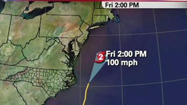
Posted — UpdatedAs of 10 p.m., the Category 4 storm, packing 135 mph winds, was moving northwest at 14 mph, and was forecast to potentially brush the North Carolina Outer Banks late Thursday, before curving back out to sea, potentially swiping New England or far-eastern Canada.
A hurricane watch means sustained winds of 74 mph or higher, torrential rain and flooding surge within the next 48 hours.
How Earl could directly affect North Carolina is still unclear, but WRAL Chief Meteorologist Greg Fishel said the storm looks like a threat mainly a threat to the Outer Banks.
"If the storm tracks a little farther west, then all of a sudden, the impacts begin to increase significantly for the Outer Banks and the sounds," Fishel said. "It would take a pretty big shift in the track for there to be a major problem, farther south toward Wrightsville Beach."
Hyde County emergency officials declared a state of emergency Tuesday night and ordered a mandatory evacuation for all visitors and beginning at 5 a.m. Wednesday.
Dangerous rip currents, storm surge and coastal erosion, however remains a threat for the entire coast. Wave are expected to peak at 17 feet at Cape Hatteras and 6-9 feet at Wrightsville and Atlantic beaches.
At Wrightsville Beach, lifeguards had to rescue 20-year-old swimmer Tuesday afternoon after she was carried out by a rip current.
"I don't know how to describe it," Esther Bernard, said. "I was just swimming, and I wasn't getting to the beach. It was scary. I was stuck there."
A similar scene played out at Cape Hatteras.
Earl was projected to travel east of the Turks and Caicos Islands Tuesday evening. It's expected to weaken to a Category 2 storm as is sweeps past the North Carolina coast just in time for the Labor Day weekend.
By 2 p.m. Friday, maximum wind speeds are predicted to be at 110 mph.
The storm delivered a glancing blow to several small Caribbean islands on Monday, tearing roofs off homes and cutting electricity to some, but there were no reports of death or injury.
Craig Fugate, administrator of the Federal Emergency Management Agency, said other evacuations might be necessary along the eastern seaboard later this week if the storm does not veer away from the coast as expected.
“Today is the day to make sure you have your plan completed and your supplies in place,” Fugate said.
There were no other residential evacuations planned Tuesday evening, but state and local emergency management officials were watching the storm to determine how to proceed.
"It is clear that once a storm is off the coast, you've got to get ready, and that's what I'm urging the people of North Carolina to do," Gov. Bev Perdue said.
Perdue urged anyone living on the coast to gather supplies for a hurricane preparedness kit, including medicine, evacuation maps and other supplies.
"Only we can take care of ourselves," she said. "We're going to be prepared."
National Park Superintendent Russel Wilson announced in a statement Tuesday that Cape Lookout National Seashore is also evacuating visitors and will be closed to the public starting Wednesday.
A number of visitor centers, including Ocracoke, Hatteras Island, Bodie Island, Wright Brothers and Fort Raleigh, will also close, as well as the Ocracoke, Frisco, Cape Point and Oregon Inlet campgrounds
The park service plans to close the Cape Hatteras Lighthouse with the last climb being at 2 p.m.
The North Carolina Department of Transportation was also preparing to respond to Hurricane Earl with warnings about road closures, flooding, ferry cancellations and evacuation routes even if telephones die.
It is readying bulldozers, electronic signs and other equipment in case of damage, and it will provide instant information about travel conditions through its feeds on Twitter, which is accessible on handheld devices, even if landline telephone service and electricity are disrupted.
So is the American Red Cross, which began deploying disaster relief teams Monday morning to areas affected by the storm.
Close on Earl’s heels, Tropical Storm Fiona formed Monday afternoon in the open Atlantic.
The storm, with maximum winds of 40 mph, was projected to pass just north of the Leeward Islands by Wednesday and stay farther out in the Atlantic than Earl’s northward path.
Fiona was not expected to reach hurricane strength over the next several days.
Copyright 2024 by WRAL.com and the Associated Press. All rights reserved. This material may not be published, broadcast, rewritten or redistributed.


