Earl threatens N.C. coast after battering Caribbean
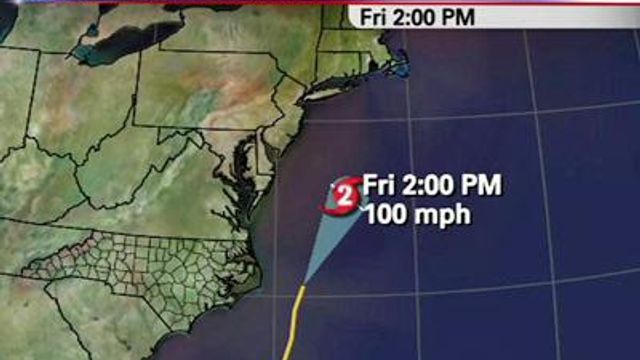
As of 2 p.m., the storm, packing 135 mph winds, was moving west-northwest at 14 mph and was forecast to potentially brush the North Carolina Outer Banks late Thursday or early Friday, before curving back out to sea, potentially swiping New England or far-eastern Canada.
Posted — UpdatedAs of 2 p.m., the storm, packing 135 mph winds, was moving west-northwest at 14 mph and was forecast to potentially brush the North Carolina Outer Banks late Thursday or early Friday, before curving back out to sea, potentially swiping New England or far-eastern Canada.
How it could affect North Carolina is still unclear, and the U.S. National Hurricane Center warned coastal residents from North Carolina to Maine to watch the storm closely.
By Thursday morning, Earl could bring rip current danger and cause heavy surf and coastal erosion along the Southeast Coast, including all of North Carolina.
"If the eye falls somewhere in the left side of the forecast fan, it could have some major impact on the Outer Banks," WRAL meteorologist Elizabeth Gardner said. "If it stays right in the middle of the fan, there's still going to be some impact, but the chance of hurricane-force winds are not great."
In fact, the chance is only 16 percent chance at Cape Hatteras – much lower than the probability of tropical storm-force winds: a 58 percent chance at Cape Hatteras and a 33 percent chance in Wilmington.
"We have the potential, even as far inland as the Triangle-Fayetteville area, but the chance is small – a 15-16 percent chance that we would have winds up to 40 mph," Gardner said.
Earl is projected to weaken to a Category 3 storm as is sweeps by the North Carolina coast just in time for the Labor Day weekend.
By 8 a.m. Friday, maximum wind speeds are predicted to be at 115 mph.
Earl delivered a glancing blow to several small Caribbean islands on Monday, tearing roofs off homes and cutting electricity to some, but there were no reports of death or injury.
Craig Fugate, administrator of the Federal Emergency Management Agency, said evacuations might be necessary along the eastern seaboard later this week if the storm does not veer away from the coast as expected.
“Today is the day to make sure you have your plan completed and your supplies in place,” Fugate said.
Close on Earl’s heels, Tropical Storm Fiona formed Monday afternoon in the open Atlantic.
The storm, with maximum winds of 40 mph, was projected to pass just north of the Leeward Islands by Wednesday and stay farther out in the Atlantic than Earl’s northward path.
Fiona was not expected to reach hurricane strength over the next several days.
"We're not going to be too concerned with this storm over the weekend," Gardner said. "If you're going to the beach, the weather should be fine, but there will still be rip current danger because of Fiona."
Copyright 2024 by WRAL.com and the Associated Press. All rights reserved. This material may not be published, broadcast, rewritten or redistributed.


