Sunday will be wet, cold, but not white
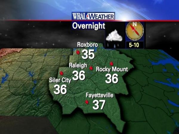
After an overnight low in the mid 30s, Sunday will see continued cold with the added attraction of some steady rain, WRAL meteorologist Nate Johnson said.
Posted — Updated
Temperatures never got out of the 40s Saturday and had dipped back into the 30s after the sun set.
"A pretty chilly air mass even for this time of year has moved into North Carolina," WRAL meteorologist Mike Moss said.
After an overnight low in the mid 30s, Sunday will see continued cold with the added attraction of some steady rain, WRAL meteorologist Nate Johnson said.
Rainfall is likely throughout the day with the heavier downpour and possibility of thunder in the counties.
"Some parts of the Triangle could see an inch or more of rain," Johnson said. The rain will diminish toward late afternoon, but some clouds may persist through Sunday night.
Further to the west, that precipitation could take the form of sleet and ice, according to the National Weather Service.
The low-pressure system developing off-shore North Carolina was producing very different weather across the state.
The predicted rainfall help prompt the extension of flood warnings for the Neuse River at Kinston, the Tar River at Greenville, the Lumber River at Lumberton and the Roanoke River in Martin County.
Forecasters say the cold rain could have a few sleet pellets mixed in as far south as Charlotte, but no problems are expected.

• Credits
Copyright 2024 by WRAL.com and the Associated Press. All rights reserved. This material may not be published, broadcast, rewritten or redistributed.


