Dusting of snow possible overnight
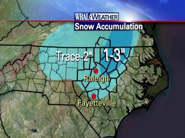
The Triangle and areas to the north can expect anywhere from a dusting of snow to 3 inches. Northern counties have the best shot at snow, but there likely won't be enough moisture behind the cold front to keep snow falling steadily Tuesday morning.
Posted — Updated
"This is the kind of stuff that drives people nuts – when it's in the 60s and literally hours later, it's snowing. But this is the kind of thing that happens," WRAL Chief Meteorologist Greg Fishel said.
Monday evening, winds shifted to the northwest, temperatures started to drop quickly, and rain began to fall.
The rain will change to wet snow in the Triangle around 1 a.m., and in Fayetteville around 3 a.m. By the time snowfall dissipates around daybreak, a dusting to 3 inches could have have fallen, with 2 to 3 inches possible in "a few lucky spots" around Warren, Halifax, Nash and Franklin counties.
But all that snow will stick to only grassy surfaces – not streets or highways.
"The thing is, temperatures will be staying probably above freezing across well over 90 percent of the (WRAL viewing) area all night long," Fishel said.
"The roads will be fine tomorrow morning. They'll just be wet," he continued. "We do not anticipate this being a major road problem tomorrow morning at all."
After a chilly Tuesday with a high around 44 degrees, another another strong upper-level disturbance and a pocket of cold air will arrive in the early evening. Forecasters predicted that a light band of snow would fall across the viewing area Tuesday night, and flurries could linger as far south as Fayetteville into Wednesday morning.
And with temperatures dropping into the mid 20s that night, Wednesday's morning commute could be more troubled, Fishel said.
"With temperatures below freezing, that could create some road problems on Wednesday morning," he said.
Cold temperatures will keep their hold on central North Carolina through Thursday. But on Friday, temperatures will shoot up, jumping to near or over 60 degrees for several days.
"We'll have very cold weather, at least by North Carolina standards, Wednesday and Thursday. And then, look, bang! 58, 67, 70 (degrees) – just like that," Fishel said.
"What's likely to happen over the next seven days is just bizarre, just nothing short of bizarre."


• Credits
Copyright 2024 by Capitol Broadcasting Company. All rights reserved. This material may not be published, broadcast, rewritten or redistributed.


