Sunshine dominates in Triangle; Beryl could bring showers to coast
Tropical Storm Beryl formed just before 11 p.m. Friday night, about 300 miles off the coast of South Carolina, and it could impact weather along the southeast coast for the next couple of days.
Posted — Updated
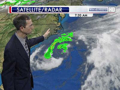
Tropical Storm Beryl, which formed just before 11 p.m. Friday night about 300 miles off the coast of South Carolina, could bring showers and thunderstorms to beach communities from Cape Hatteras to northern Florida over the next couple of days.
"Beryl has been maintaining about the same strength it had last night," Moss said. "It's got 45 mph sustained winds right now and is moving slowly to the southwest."
The best chance for rain and storms at North Carolina's beaches will come Saturday, when rain and thunderstorms could stripe coastal areas from Hatteras to Wrightsville Beach. High temperatures will hover near 80 degrees along the southern portions of the North Carolina coast.
The Red Cross on Saturday warned swimmers about strong rip currents, advising beach-goers to swim only on lifeguard-protected beaches within designated swimming areas. Rip currents could become more powerful and frequent Saturday evening as Beryl draws closer to the southeast coast along South Carolina.
The Red Cross also provided several tips for swimmers who may become caught in a rip current:
- Never fight against the current.
- Swim out of the current in a direction following the shoreline. When out of a current, swim at an angle toward the shore.
- People unable to swim out of a rip current should float calmly or tread water.
- People unable to reach the shore should draw attention to themselves by waving their arms and yelling for help.
- Stay at least 100 feet from piers and jetties, as permanent rip currents often exist near them.
- If someone is in trouble, get a lifeguard for assistance.
In the Triangle, Saturday's weather will be perfect for outdoor activities. Temperatures will climb into the low 80s by lunchtime and top out in the upper 80s by mid-afternoon.
"We're going to see lots of sunshine in central North Carolina today," Moss said. "It'll be humid and muggy, but overall, it will be a nice day to be outside."
Beach-goers willing to wait out Saturday's storm threat could see more sun Sunday and Monday at the beach as Beryl continues to filter toward the southwest.
"It's going to make landfall sometime Sunday afternoon in the area of the Georgia-Florida border," Moss said. "It'll probably have 50 mph winds, and it will just kind of linger in the southeast for a couple days before a front kicks it out early next week."
Moisture associated with Beryl could produce a widely scattered shower or thunderstorm in the Triangle Sunday or Monday, but rain chances shouldn't be high enough to cancel holiday weekend plans, Moss said.
Holiday travelers head east
The threat of overcast weather did not stop Triangle residents from streaming eastbound on Interstate 40 Friday afternoon.
AAA Carolinas expects more people to leave home this holiday weekend than at the same time last year. About 30.7 million people will drive more than 50 miles, the group said. Half of those surveyed by AAA said they'll travel less than 400 miles.
Travelers will reap the benefits of gas prices that have been dropping for the past month. On Memorial Day weekend of 2011, the average price per gallon was $3.73 in North Carolina. This year, it is $3.52.
AAA doesn't expect a significant pick up in travel until employment, incomes and consumer spending show greater gains and the housing market turns around. It sees signs of that happening next year. For now, travel remains well below the pre-recession peak of 2005, when 44 million people traveled for Memorial Day weekend.


• Credits
Copyright 2024 by WRAL.com and the Associated Press. All rights reserved. This material may not be published, broadcast, rewritten or redistributed.


