
The future progression of extremely powerful Hurricane Igor is proving tough to pin down if we look past the typical 5-day official projections from the National Hurricane Center. Of course, the uncertainty inherent in making weather forecasts farther out in time than that is one reason those official tracks stop at five days, but it can be interesting to look farther out at the level of agreement, or lack thereof, between various forecast models. Often, when several agree closely, the eventual path is reasonably well represented, while a great spread in solutions reduces confidence about such predictions.
Two of the dynamical forecast models, those that attempt to calculate the future state of the atmosphere and features within it rather directly, that have done best in the past couple of years at predicting future locations of tropical cyclones have been the European Center for Medium Range Weather Forecasting (ECMWF) model, and the American Global Forecast System (GFS). So far this year as well, both have done a pretty good job with most of the tropical storms and hurricanes that have developed in the Atlantic, and in most cases have generated forecasts that stayed in reasonably good agreement with each other.
For the past couple of days, however, they have come to a major parting of ways on the eventual track of Igor, and it remains a couple of days too soon to begin having some confidence about which one is closer to correct. The GFS remains pretty consistent in showing a path that curves northwest then north and accelerates into the north Atlantic, perhaps passing east of Bermuda over the weekend. A few days back the ECMWF hinted at a similar turn. For the past two days, though, the ECMWF has slowed the system and "trapped" it at lower latitudes, and now shows the storm well south-southwest of Bermuda and still with a northwesterly motion late in the weekend. This is still suggestive of an eventual pass somewhere between the U.S. and Bermuda, but bears watching for any further tendency to move closer to the east coast.
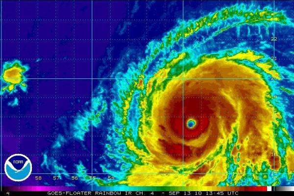
It will be very interesting in the next 2-3 days to see which model, if either, trends toward the other, or if they meet somewhere in the middle, as newer observations are made and the storm continues along its path. Fairly often, but certainly not always, the ECMWF tends to be a leader at longer forecast ranges, with other models adjusting to its patterns - its still too early to know if that will be the case with this storm. For a sense of the current spread in forecasts, see the two forecast maps I captured from the Penn State e-wall Tropical Section that follow the Monday morning satellite image. The first shows the sea-level pressure pattern for Sunday evening 19 Sep 2010 at 8 pm, from the GFS. The position of Igor is obvious from a glance at the isobars (lines of equal pressure). The second image is identical, for the same time, but from the ECMWF.
From a climatological perspective, ten major hurricanes have passed within 2 degrees of latitude or longitude of Igor's current position in September. Of those, 5 passed east of Bermuda over the open Atlantic, and 5 passed west of the island. Only one of the ten made landfall in the U.S. - that history doesn't offer a guarantee, of course, but it does suggest that storms in Igor's location typically bypass the mainland.
Copyright 2024 by Capitol Broadcasting Company. All rights reserved. This material may not be published, broadcast, rewritten or redistributed.


