
We'd been watching a system for several days that posed both the opportunity for some welcome and significant rainfall as well as a threat for severe weather, and it finally made its passage across the area yesterday and last night. In general, the news was good as the system pretty well followed along the path and timing that had been forecast for the past several days, with a few sprinkles and stray showers during the day and the "main event" with heavier showers and strong thunderstorms late yesterday and into the evening.
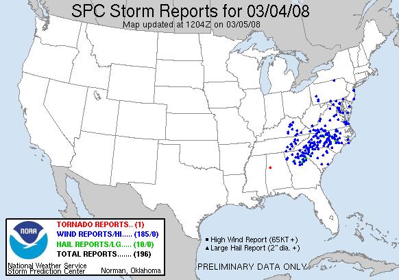
There were some signs that this system had the potential to produce tornadoes in addition to some strong wind gusts, and this prompted the Storm Prediction Center in Norman OK to both place us in a "moderate risk" area for severe weather and eventually hoist a tornado watch for the viewing area as the storms approached. Luckily, while wind fields, vertical motion, and the general pattern associated with the system were favorable, instability was lacking and may have been the principle factor that limited tornado formation as the system passed. We did, however, end up with bands and cells that produced rather numerous wind gusts into the 50-70 mph range (58 and above qualifies as severe), which resulted in numerous reports of trees down and some power outages. As is typical with winds in this range, there wasn't much direct structural damage to homes or businesses, although we have seen isolated reports of houses or mobile homes damaged by trees. The attached map from the Storm Prediction Center gives a good idea of how numerous the reports of high winds were, with those reports in blue, hail reports in green and tornado reports in red.
The system had a much more beneficial side as well, of course, with heavy showers and storms resulting in significant rainfall across most of our region. Measured amounts fell mainly into the range of one-half to one and one-half inches, but there were a few streaks in the 2-inch range, including an even 2.0 inches at the Raleigh-Durham airport, and a few streaks where amounts were lower, in the quarter to half-inch range. We also saw about 1.5 inches at Greensboro, 1.1 inches at Roanoke Rapids, and three-quarters of an inch at Winston-Salem and Fayetteville.
You can get a sense of how the rain was distributed from the second image above, a radar rainfall estimate from the Plymouth State University NEXRAD archive. One notable area with lower rainfall amounts stretches from about the middle of Franklin County near Louisburg southwest across parts of Wake County and on to central Hoke County near Raeford, but even here it was a decent rainfall for a single event. On the other hand, the area from about Raleigh-Durham north and west appears to have averaged about an inch and a half, which could have a very beneficial short-term impact on the lakes (like Falls and Michie) that depend on the upper Neuse river watershed - this is an area that has missed out somewhat on several other notable rainfall events in recent months, so it will be interesting to watch lake levels over the next several days and see how they respond. Another useful resource for checking precipitation totals is the CoCoRAHS web site - a map of totals from this storm for Wake County is the third image above. To see any county in the state, just go to http://www.cocorahs.org/state.aspx?state=nc
Computer models are indicating another round of potentially significant rainfall later Friday into early Saturday as low pressure develops near the northern Gulf of Mexico and tracks toward the northeast, so with any luck we may moisten up a little more in just a few days.
Copyright 2024 by Capitol Broadcasting Company. All rights reserved. This material may not be published, broadcast, rewritten or redistributed.


