
We received a press release recently that was a good reminder that some weather instruments in use by our government play some interesting and important roles beyon that of serving a purpose in weather analysis and forecasting. While the constellation of weather satellites in orbit around the Earth play an indirect role in public safety by adding to the datasets that support reasonably accurate forecasts of potentialy hazardous storm systems (by way of satellite imagery as well as more esoteric measurements of water vapor content, cloud motion vectors, vertical temperature and dew point profiles, and so on) there is a subset of the meteorological satellite system that plays a much more direct role, and does so in a nice spirit of international cooperation.
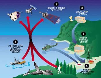
It is called the COSPAS-SARSAT system, COSPAS being the name of a system that flies on Russian navigation satellites that translates to "Space System for the Search of Vessels in Distress" and the SARSAT part being a U.S. "Search And Rescue SATellite" system. The U.S. portion of this system piggybacks on NOAA Polar Orbiting weather satellites that track along in low earth orbit at a little lower than 600 miles. The Russian COSPAS satellites have slightly higher polar orbits or a little over 600 miles.
The combined systems, together with electronic components contributed by Canada and France, maintains a constant vigil for any transmissions from emergency locator beacons activated by those in distress associated with airplane accidents, incidents at sea, medical emergencies and other uses. The system is designed so a beacon activated just about anywhere on the planet will be detected and have its location estimated and retransmitted to ground stations within an hour and a half, often much sooner. For U.S. incidents, these signals are centrally processed by NOAA at a Maryland operations center, with rescue requests immediately passed on to the U.S. Coast Guard for water emergencies, and to the U.S. Air Force for those in land areas.
In 2007, the system played a major role in the rescue of 353 people in the U.S. and surrounding waters, sixteen of which were here in North Carolina. That placed our state third nationwide in use of the system, while Texas and Florida tied for first at 73 people rescued. All told, the system has assisted with the rescue of some 22,000 people worlwide in 25 years of operation, 5700 of which were in the U.S. or nearby waters.
In the past, emergency locator beacons were fairly bulky pieces of equipment mainly limited to ships and aircraft. In recent years, though, personal beacons have become available for anyone who is undertaking a trip where the potential need for rescue is an issue and where cell phone communication may be unavailable.
----------
On a barely related note (but at least having to do with travel and pictures!) I was asked to remind everyone about our ongoing "USA Getaways" photo feature that runs during the Saturday and Sunday morning newscasts. We invite you to send us shots that you especially like from your travels around the country (including our home state) and they will be featured both on the air and on the web site - to submit your shots, or view a slide show of those sent in by others, just type "getaways" into the search box at the top of any page on our site. I just submitted one myself, from a favorite getaway spot on the banks of the Pamlico River in Beaufort County...
Copyright 2024 by Capitol Broadcasting Company. All rights reserved. This material may not be published, broadcast, rewritten or redistributed.


