
The storm system that crossed the southeastern U.S. this weekend lived up to its advance billing as a good rainmaker for the Tarheel State, and in combination with two other lesser systems in the past week left us with a very helpful week of rain across most of the state - it doesn't represent an end to our drought or to the need for careful water use, but certainly was a nice reprieve from continued worsening of the dry spell.
Some of the numbers for precipitation with the front and low that affected us Sunday include 1.92 inches at RDU, a new daily record that left us with a monthly total for December (4.45 inches) that exceeds normal by just over an inch and a half. In Fayetteville, .93 inches fell at the airport. We also had reports that included 1.2 inches at Burlington, .83 inches at Rocky Mt-Wilson and .84 inches at Seymour Johnson AFB in Goldsboro, 1.7 inches at Chapel Hill, and 2.2 inches at the NWS Office at NCSU, 1 inch at Tarboro and 1.8 inches at Henderson. I had about 1.9 inches in my rain gauge (off Holly Springs road halfway or so between Raleigh and Holly Springs) for a total of just over 2.5 inches for the past week.
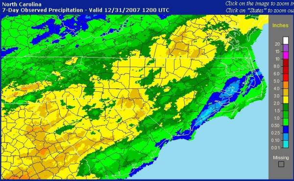
Across the region, the past week provided pretty extensive coverage for the state as a whole (see the precipitation analysis map) with only a few pockets in the mountains and several coastal counties receiving less than one inch. Of special note is that we saw 1-3 inch totals across much of the upper Neuse basin and 2-3 inches across the upper Haw/Cape Fear and Tar river basins, which should provide at least some short-term benefit for some of the area reservoirs (in fact, Falls Lake rose slightly from Dec 28 - 30, and then almost another foot between 9 am Sunday and 9 am today). There area also a couple of areas just across the border in south-central VA and just southwest of our viewing area across the southern Piedment of our state that picked up 3-4 inches during the last seven days.
I mention short-term regarding the benefits because, while we can't rule out some changes along the way, current projections do not indicate much chance of substantial rain over the next week to ten days or so, with the longer range portion of those outlooks indicating a return to above-normal temperatures after a rather sharp intrusion of much colder air later on New Year's Day and lasting into the latter part of this week. After some of the mild weather recently (71 the high at RDU Saturday!) it may be a bit of a shock to the system.
Although it appears to be a very minor event, the arrival of the really cold air Tuesday night and early Wednesday still shows signs of being accompanied by a strong upper level disturbance and very cold pocket of air aloft that could potentially generate a few snow flurries, most likely unmeasurable due to a lack of substantial moisture, somewhere between the pre-dawn hours and midday or so on Wednesday. Those of us who do not see any flakes should certainly feel the colder air, though - winds will become blustery from the northwest with morning temperatures in the 20s and highs in the upper 30s to around 40, with wind chills in the teens and 20s. Bundle up!
Copyright 2024 by Capitol Broadcasting Company. All rights reserved. This material may not be published, broadcast, rewritten or redistributed.


