Ending the Year...
We'll finish off 2007 with dry weather and sunshine on December 31st, but we are at least in the process of receiving a good dousing of rain across much of the area.
Posted — Updated
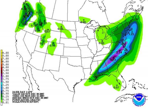
We'll finish off 2007 with dry weather and sunshine on December 31st, but we are at least in the process of receiving a good dousing of rain across much of the area a day before that, and the combination of a nearly stalled frontal boundary, a surface low traveling along that boundary, an upper level trough to our west and a broad fetch of moisture flowing in from the south and southwest should give most of us somewhere between one half and two inches of rain as we close out the last weekend of the the year. That may sound like a broad range of rainfall amounts, and it is, but even in very favorable scenarios for widespread rain, small scale effects can lead to pockets and bands of lighter and heavier precipitation. As of this writing, we'd already reached 4 tenths of an inch on the roof here at WRAL, along with about 4-5 tenths at Chapel Hill and RDU, and almost 7 tenths at Fayetteville. While there are never absolute guarantees, even with an event in progress, this should be a very beneficial rainfall for most of our area, including the upper watershed regions of the Neuse, Haw/Cape Fear, and Tar rivers, as indicated in the estimate of forecast rainfall amounts from the Hydrometeorological Prediction Center (above).
Of course, even a very nice rainfall like this one does not in itself signal an end or a major amelioration of our drought, and unfortunately current forecast models indicate a lengthy dry stretch is quite possible as soon as this rain departs the area tonight. While changes in the forecasts can't be ruled out, current projections indicate that we could go eight or ten days before our next measurable precipitation, so we do need to keep those water conservation practices going.
One aspect of ending the year is that the statistic you hear a lot about (rainfall anomaly since Jan 1st) will reset to zero on New Year's Day. Of course, this statistic is one that is meant to be most useful in years to come for looking back at the year 2007. Because of the interest in how the current values of that deficit change over time, the National Weather Service will add a section to their daily climate reports that shows the anomaly since the beginning of 2007, in addition to the new one for 2008, and we will make that value available on our web site. Of course, over the long run it can be more consistent to use a sliding window, and that is what we do (covering the past 30, 90, and 365 days) on our RDU rainfall graphs, available through our "Almanac" page.
A couple more quick points about finishing the year and kicking off 2008. It appears that New Year's Eve celebrations outdoors will enjoy fair skies this year, with temperatures falling from around 50 in the early evening to the low 40s by midnight. A cold front later on New Year's Day will begin to usher in the first Arctic outbreak of 2008 for our area. The cold air blast is likely to be felt full-bore by Wednesday, when we'll have gusty northwest winds and highs that top out in the upper 30s to around 40 in spite of of some sunshine. Also, there are some weak indications that the passage of a sharp upper level trough and very cold pocket of air aloft late Tuesday night and very early Wednesday could generate a few flurries across the area, although moisture appears quite limited and we may turn out dry enough to preclude any precipitation - just something to keep an eye on. Meanwhile, enjoy the rain!
Copyright 2024 by Capitol Broadcasting Company. All rights reserved. This material may not be published, broadcast, rewritten or redistributed.


