Watch for Falling Records
A summer-like pattern ignores the calendar and generates record warmth across much of North Carolina this week.
Posted — Updated
The calendar says it's December, but Mother Nature is having none of that!
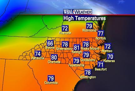
A very summerlike pattern has taken hold across the southeast, thanks to an area of high pressure centered around the island of Bermuda. Frequent weather watchers may recall that a "Bermuda High" is a common feature around these parts during the summertime. It's showing up out of season, and the results are following suit. Temperatures more akin to what we expect in May were the rule today, and more of the same is in the forecast through mid-week.
Here's a look at the record high temperatures for RDU through Friday, as well as the WRAL forecast highs for the same days. If the forecast verifies, we'll break at least three records at RDU this week:
We're also seeing record territory in Wilmington. Today's high of 78° was good enough to tie the current record set in 1966, and more record warmth is on the way:
High Temperatures (Wilmington)ILMTue 12/11Wed 12/12Thu 12/13Fri 12/14Record77° (1985)79° (1931)80° (1956)79° (1956)Forecast78°79°77°70°
Cold weather lovers, fear not: a series of cold fronts and a significant pattern shift could bring temperatures back to below normal levels by this weekend.

Copyright 2024 by Capitol Broadcasting Company. All rights reserved. This material may not be published, broadcast, rewritten or redistributed.


