I live in Siler city and I know our water supply is getting very low, but my question is and i can't find it anywhere is what exactly is what is our rain deficit exactly..Do you see any substantial rain in the forecast at all that will help us here?
Posted — Updated
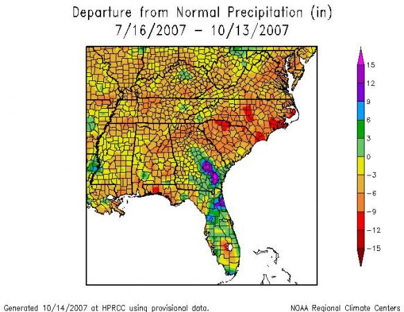
MIKE MOSS SAYS: Jenny, Based on readings from the Siler City Airport and normals for Siler City available through the Southeast Regional Climate Center (SERCC) web site, the Year-to-Date rainfall deficit for the airport is about 21 inches (only about 44% of normal). Contour maps available from the NWS and the SERCC, like the one above, based on a combination of gauge reports and radar rainfall estimates, indicate year-to-date deficits around 15-17 inches.
Using year-to-date values can be misleading (though not always) since the value resets to zero on New Year's day, so a better way to view defecits can be a sliding window of various time scales. The map I included shows rainfall anomalies for the past 90 days, and you can see the dark red color across the western half of Chatham County that indicates about a 9-12 inch deficit for the region over that time period.
As for future rain, in the short-term it appears we'll stay mostly dry through Thursday or so (slight chance of a sprinkle or shower Wed-Thubut many of us probably missing out on measurable rain) but may have a chance at a decent band of showers Friday or Saturday. Of course, it's too soon to have much confidence about specific forecasts that far in advance. In terms of more general climatological probabilities, the development of a La Nina pattern in the Pacific may lean the odds for our region toward below normal rainfall for the winter season, while there seems to be a window between now and then when chances of above or below normal rainfall are assessed as just about equal. Unfortunately, nothing jumps out as a good indicator for drought-busting rains ahead very soon.
Copyright 2024 by Capitol Broadcasting Company. All rights reserved. This material may not be published, broadcast, rewritten or redistributed.


