Finally, Some Rain...
After a couple of days in which we forecast a small chance of rain, mainly south of the area, and then most of the rain was concentrated toward the south even more than initially expected, we finally got rainfall across a widespread area on the day it was most expected.
Posted — Updated
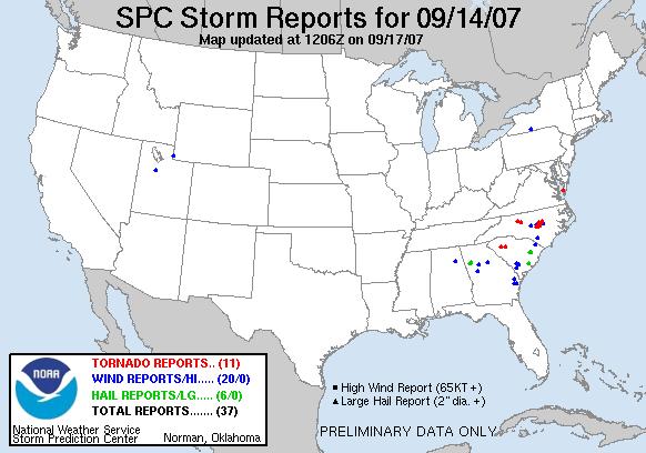
After a couple of days in which we forecast a small chance of rain, mainly south of the area, and then most of the rain was concentrated toward the south even more than initially expected, we finally got rainfall across a widespread area on the day it was most expected, with Friday and Friday night bringing lots of rain to much of the Tarheel state. A frontal boundary that had stalled to our south combined with an approaching upper level trough, an approaching reinforcing cold front, and moisture that had been associated with Humberto to set off numerous heavy showers and thunderstorms that crossed the state from west to east in a series of bands, clusters and cells, a few of which became supercellular, with rotating circulations that produced gusty downburst winds, quite a few funnel cloud reports, and at least seven reported tornado touchdowns across central NC. There were also a couple of tornadoes reported in western SC and a Chesapeake Bay waterspout that moved ashore over eastern VA, all indicated in red on the severe weather reports map shown above (from the Storm Prediction Center).
There were some damage reports from around the area, including some from downburst winds, but luckily the tornadoes were at the low end of the intensity scale, with the National Weather Service in Raleigh indicating they were classified as EF-0 storms, with wind speeds likely in the 65 to 85 mph range.
The other major impact of the system was at least some degree of temporary drought relief. Although many officials are correct in pointing out that we can't assume one good rain signals a major break in the ongoing drought, it certainly helps a little and any recovery from dry conditions has to start somewhere. This storm complex left behind rainfall across the state that ranged anywhere from around one-half inch to around 5 inches in some of the heavier streaks. In our area, the RDU airport received a little over 1.9 inches for new daily record, and 1-3 inch totals were common (I got two inches in my gauge at home, about halfway between Raleigh and Holly Springs), while parts of southern Wake, northern Cumberland, Harnett and Sampson, and much of Johnston county saw as much as 3-5 inches, indicated by the red shades on the 24 hour precipitation map (#2) above, from the NWS Precipitation Analysis site.
One notable drawback to the rainfall pattern that can be discerned in the map above is a relative minimum in rainfall accumulation marked by the blue band that roughly runs along the I-85 corridor. Rainfall here was mainly a respectable one-quarter to one inch, but this minimum corresponds to the upper quarter or so of the Neuse, Tar and Cape Fear River basins, which could limit somewhat the benefits to inflow for Jordan and Falls Lakes (both of which increased a little in elevation over the weekend but have begun to drop a bit already), and perhaps the Rocky Mount reservoir as well. There was another area of very heavy rain with the system farther northwest, with most of that falling over the Yadkin-Pee Dee and Roanoke watersheds.
In the wake of the rains, we still have a sizable deficit in rain versus normal. As an example, see the map indicating rainfall as a percentage of normal for the past 60 days, showing that a large part of the state is at around 25-75 percent of normal for that period, with some small pockets that have been a little wetter, and also some pockets (red) that have had less than 25 percent even after the Friday rains.
Climate outlooks for the next couple of weeks indicate a trend toward somewhat warmer temperatures and a tendency toward less than normal precipitation. There is a potential for a trough along the coast to bring some scattered shower activity to central and eastern parts of the state from later Wednesday into Saturday, due to a coastal front/inverted trough running north from a developing low off the Florida coast. However, model guidance is highly varied on how this system will evolve, with some models indicating precipitation that would be mainly suppressed to areas south of us, and confidence in any substantial rain here during that time remains rather low.
Copyright 2024 by Capitol Broadcasting Company. All rights reserved. This material may not be published, broadcast, rewritten or redistributed.


