
The title of this post almost begs to be followed by something like "we hardly knew ye..." as indeed this was a storm that had very little impact across the bulk of the WRAL viewing area, apart from possibly enhancing temperatures a bit by virtue of the so-called "moat" effect in which sinking air around the periphery of a tropical cyclone can lead to mainly clear skies and heating of the air through compression. We ended up with a high of 95 at the RDU airport on Sunday as Gabrielle moved across the eastern edge of the state, which incidentally was the high temperature that broke the RDU record for days in a calendar year that reach or exceed 90 degrees. In 1953, that record was established at 72 days, and we reached 73 for 2007 on Sunday afternoon. It appears we'll run it to at least 75 this week, before a pattern change that should leave us notably cooler for the second half of the week and into the weekend. In mentioning this record, it is worth noting that it is specific to the observing site at RDU. Various other sites served as the "official" reading for Raleigh going back to 1887, and in 1941, when the old Raleigh Municipal Airport was the station of record, 90 degrees was reached or topped 82 times.
Gabrielle turned out to be a reasonably well-forecast system, though you can always look back and wish for a little more certainty along the way. As early as Labor Day or a little before, we picked up on the idea that weak low pressure off the SC/GA coast would likely push east into the Atlantic, then stall and backtrack toward the East Coast. At that time, the potential combinations of steering influences covered a wide spread, and at least a few models, including the often-reliable European Center for Medium Range Weather Forecasting (ECMWF) model, indicated the storm might make landfall in GA or SC and track north into our state with beneficial rains for central and eastern Carolina. Someothers kept the system completely out at sea. As the storm began to actually track west, of course, and newer data and analyses became available, it grew more apparent that Gabrielle was likely to follow a recurving path that brought it across easternmost parts of the state or possibly just east of the Outer Banks, and the main question became the potential for intensification. There were factors that argued both for inhibiting the storm (anticipated periods of notable vertical wind shear, first from the southwest, later from the northeast, along with a wide band of deep, dry air just west of the system, available for occasional entrainment) and for potential strengthening (a couple of periods in which vertical shear was predicted to weaken, and also a band of deeper warm water with surface temperatures in the 84 degree range not far off the coast). While computer models, not to mention human forecasters, do not have a sterling history when it comes to intensity forecasts, the general idea with Gabrielle was that it would likely remain a tropical storm, but with a small potential to become a low-end hurricane if its passage across the greatest oceanic heat content (a factor that combines both temperature and depth of warm water) corresponded with a period of little vertical wind shear. In the end, the storm did strengthen a little as it crossed those warmest waters and wind shear weakened, but that window closed rapidly as vertical shear once again picked up and displaced the strongest convection from the low level circulation center in the last several hours of its approach to the southern outer banks.
The result was was a storm that topped out with sustained winds in the 45-55 mph range as it crossed the sounds, produced relatively narrow advance feeder bands of scattered moderate to heavy showers, and generated a more concentrated band of very heavy rain that trailed it to the southwest (in the "downshear" direction). This trailing band of rain mainly fell back into ocean waters, but did build into a small part of the mainland just south of the Neuse River and Pamlico Sound, especially over Carteret and Craven Counties. While most of eastern NC received well under an inch of rain from Gabrielle, there were some very impressive totals within this one area. Beaufort recorded 7.4 inches, the Newport NWS office got 5.4, and the Cherry Point MCAS had 4.5 inches of rain, all in just a few hours. On the other hand, Cape Hatteras only got about .23 inch, Ocracoke .34 inch and Greenville .45 inch. One cooperative observer near Beaufort reported a little over 8 inches from the storm. Closer to us, a band or two of showers tracked as far west as about a Jackson to Greenville to Kinston line, leaving most of us high and dry with no assistance in terms of the ongoing drought. The highest sustained winds measured at land stations were 39 mph at Cape Hatteras and 33 mph at Beaufort, while gusts reached 61 mph at Ocracoke and 53 mph at Cape Hatteras.
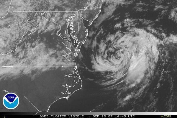
Today, Gabrielle has been downgraded to a Tropical Depression and continues to pull away into the Atlantic to our northeast, as seen in the visible satellite image above. We'll continue with heat today and tomorrow, but a frontal boundary northwest of us should slide into the region as the week wears on, bringing temperatures back to normal and offering up at least a somewhat better chance of periodic showers or storms, especially as we get to Thursday and Friday. We can't be certain yet, of course, but there's some potential that temperatures on Friday will end up holding in the 70s, and outlooks from the Climate Prediction Center for both the 6-10 and 8-14 day periods indicate a likelihood for below normal temperatures on average across the Eastern U.S.
Copyright 2024 by Capitol Broadcasting Company. All rights reserved. This material may not be published, broadcast, rewritten or redistributed.


