I've just returned from a vacation at Duck, NC, on the Outer Banks. The ocean water felt icy to me, so I looked up the surf temperature on a local web site and discovered it was 64 degrees. By contrast, it was in the 70s a little closer to Nags Head and in the 80s at Emerald Isle. Virginia Beach's water temp was listed as 72 degrees. We looked up ocean currents online, but none of what we found seemed to explain why the water was so much colder at the Duck/Corolla area. Do you know the answer? The owner of the cottage we rented said this was unusual. Thanks!
Posted — Updated
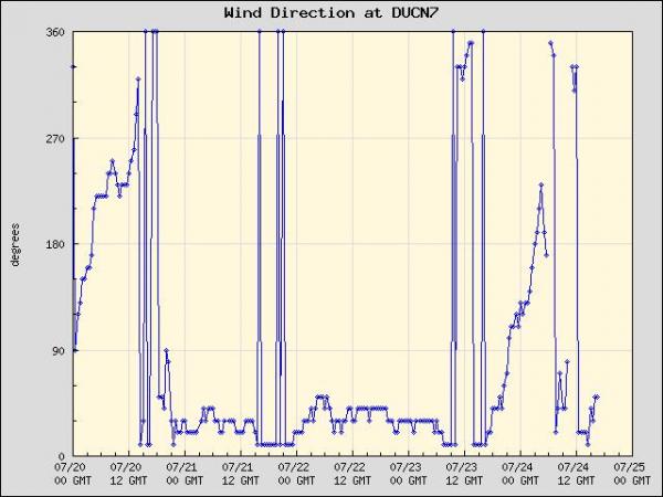
MIKE MOSS SAYS: Michelle, I wouldn't really consider that so unusual for a location like Duck that is north of Cape Hatteras, although it certainly isn't an every day or every week occurrence either. While water temperatures farther south tend to warm gradually through the late Spring and into mid-summer, edging rather steadily upward into the mid 70s to mid 80s, the areas farther north are subject to fairly frequent intrusions of colder shelf water that is pulled to the surface near the shore by an "upwelling" process. The typical pattern is for surf temperatures along the northern coast to gradually warm into the low to mid 70s (and occasionally up around 80) during periods of light and variable wind or large scale winds from the north and northwest, but to drop off into the 60s (sometimes low 60s) during notable periods of sustained south to southeast winds. The reason is that a rather deep layer of water near the surface ubdergoes a net flow to the right of the direction of the wind in a process called "Ekman Transport." When winds are weak and somewhat variable in direction day to day, this transport is negligible, and when winds are principally from the north or west, this transport is toward or along the shore of our state. In either of those cases, water at the surface and near the shore generally remains there and is subject to warming by contact with the air and by solar radiation. When the winds are southerly or southeasterly, the transport of surface water is away from the coast, and when this happens the near-shore surface water must be replaced by deeper water that flows in from the east. This deeper water remains quite cool year-round and so the temperature can drop rapidly when this process sets in. This process is much weaker and sometimes has almost no effect south of Cape Hatteras, due to the presence of the warm and deep Gulf Stream current nearby. The Gulf Stream detaches from the coast near Hatteras, though, and heads off northeast into the Atlantic, leaving our northern coast more subject to the temperature variations I just described.
The same "Ekman Transport/Coastal Upwelling" process occurs along the west coast of the United States, and is a primary reason for the chilly water temperatures and mild summertime coastal climates there, because the predominant surface wind direction across that region is from the north.
I've attached a couple of plots of water temperature and wind direction from the National Data Buoy Center for the past week in which you can clearly pick up on the modest warming from a very cool start that occurred with initial easterly winds but followed by rapid cooling associated with development of a south to southwesterly flow, and then the sustained recovery that set in after variable winds switched mostly to the north and northeast.
Copyright 2024 by Capitol Broadcasting Company. All rights reserved. This material may not be published, broadcast, rewritten or redistributed.


