Looking the Wake Doppler 5000 loop for tonight (Tuesday) around 8:00 pm, do I see two outflow boundaries south of the TS cell, one oriented NW-SE moving south and another oriented SW-NE moving SE? I've never seen two outflow boundaries converge like that.
Posted — Updated
MIKE MOSS SAYS: Chuck, Good observation, and you are exactly right. that there are visible outflow boundaries intersecting at almost a 90 degree angle to one another over the southern third or so of Wake County at that time. The boundaries themselves are areas of strong convergence and turbulent mixing that results from the spreading of air that has rushed downward out of thunderstorms and impinged on the surface. The convergence brings together a concentration of dust, flying insects and sometimes birds, and also results in turbulent irregularities of refractive index due to mixing of adjacent airmasses having different temperature and humidity characteristics. All of this actis to produce a narrow line that is weakly reflective of radar signals.
The boundaries can mark the leading edge of a region with strong winds just behind them when they are close to the parent storm cell, and generally breezy and cooler conditions at a greater distance from the origination point. They also can act as a lifting surface that can force surrounding warm, moist air upward. Depending on the amount of lift and the stability of the surrounding airmass, this can lead to either some cloud formation along the outflow, or to new shower and thunderstorms cell formation. This effect can be enhanced near the intersection of two such boundaries, or along the intersection of an outflow boundary and a different type of boundary such as a cold front or sea breeze boundary.
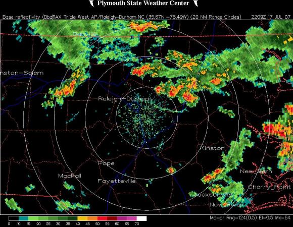
I've attached three radar images from that evening. At about 6 pm (2200 UTC), you can see a line of cells to the northeast and a strong cell to the northwest, both of which have produced the boundaries that will later converge in Wake County (the western bounary is barely visible over western Chatham County, because at that distance the radar beam, traveling outward at a one-half degree angle above horizontal, passes almost completely over the top of the boundary, which is a shallow feature that will become more clearly marked as it approaches the radar site and therefore a beam that is closer to the ground). Then at 8 pm (0000 UTC) the cell to the northwest has moved into Wake county just northwest of the boundary intersection, and finally at 10 pm (0200 UTC), several additional cells have formed, some of which appeared in loops to have been triggered or enhanced by the earlier boundaries. There is also a recently formed boundary flowing northwest out of a cell in southern Wayne County. That one is a little hard to see, but arcs from about central Johnston County southwest into northeast Harnett County.
Copyright 2024 by Capitol Broadcasting Company. All rights reserved. This material may not be published, broadcast, rewritten or redistributed.


