
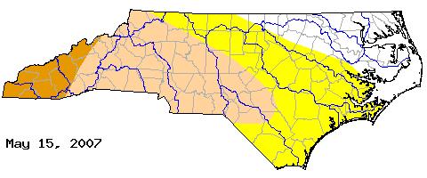
We haven't had to talk much about drought across central North Carolina for while, but conditions have been gradually drying over the past several weeks in spite of some periodic episodes of locally heavy rainfall. This week, the U.S. Drought Monitor and the North Carolina Drought Advisory Council have extended moderate drought designations eastward across the southern Piedmont and portions of the Cape Fear River basin, encompassing Chatham, Lee, Harnett, Cumberland, More and Hike coutines in the area of moderate drought, while the rest of our viewing area remains listed at "abnormally dry," with a couple of exceptions in the northern Coastal Plain. The most recent Drought Monitor map for our state is shown above, with the yellow area indicating abnormally dry, tan representing moderate drought, and orange denoting severe drought. So far, that level of drought is restricted to the southern mountains of our state. Also available in the sreies of images are 30 and 90-day graphs of rainfall versus normal for RDU, and a map of precipitation percentage of normal for the southeast. These images show that much of NC is significantly below normal for rain over that three-month span, although RDU is within a narrow band that is closer to normal than many other locations. RDU, however, is running well below normal over the past 30 days.
While a weak cold front backing into the state from the northeast today and stalling over west central NC tomorrow will offer some chance of isolated showers and storms, the coverage and rainfall amounts associated with this system will likely be meager, with many of us receiving either small amounts of rain or no measurable rain at all. Aftre that, the remainder of the week looks dry. There are some indications, however, that we may have above normal rainfall in the 8-14 day period encompassing the end of May and early June, which would be helpful in staving off deteriorating drought conditions, and long term outlooks for drough currently have most of the drought areas in our state showing some improvement through the summer. Of course, forecasts with that long a lead time are not all that high in confidence, but because of the apparent likelihood of a La Nina pattern developing in the Pacific and the tendency in La Nina years for Atlantic hurricane activity to be enhanced, we may have more opportunities than average for tropical cyclone remnants to pass through the region, something we count on in the this parts of the country to fill in some of the typical rainfall and water supply gaps in the summer when our weather is typified by plenty of heat (and high water demand) with hit and miss thundershower activity.
You can check up on drought designations around the country using the U.S. Drought Monitor web site, which is updated each Thursday, at
http://www.drought.unl.edu/dm/monitor.html (scroll to the bottom for regional drought discussions)
For information more specific to our state, check the NC Drought Management Advisory Council page at
http://www.ncdrought.org/
This site is especially useful for its links to current hydrologic conditions around the state, including listings of current streamflows and groundwater well status, water conservation measures currently in effect, and more, all available by clicking the "Current Conditions" tab at the top of the page.
Copyright 2024 by Capitol Broadcasting Company. All rights reserved. This material may not be published, broadcast, rewritten or redistributed.


