
By Mike Moss
That's a term that doesn't come up real often around our area because of the typically well distributed rainfall throughout the year, along with the relative infrequency of strong sustained winds across the region. The existence of a "Red Flag" warning was highlighted last week, though, by the way in which a combination of dry air and gusty winds fed into the major fire that occurred in the Pine Knoll Townes development on Thursday February 22nd. On that day, a Red Flag warning was issued by the National Weather Service in the afternoon, and the conditions in place did result in a number of difficult to control fires around North Carolina.
While the Pine Knoll fire was especially noteworthy, one of the largest in Raleigh history, the Red Flag warning program is really designed to address brush and wood fires. The criteria for issuing such a warning vary a bit from region to region, but for our area, the National Weather Service, in conjunction with forest service land managers, looks for a combination of the following three factors:
- relative humidity less than or equal to 25 percent (this can result from especially dry air, or from moderately dry air together with especially warm temperatures - at the time the Pine Knoll fire initiated, the temperature was 73 with a dew point of 21, for a relative humidity of 14 percent)
- sustained winds that are expected to equal or exceed 20 mph (RDU airport reported 18 mph at the time of the fire, but had 21 and 23 mph the previous two hours, and gusts were in the 25 to 35 mph range)
- 10 hour fuel moisture levels less than or equal to 8 percent. This is a value that applies to branches, twigs and the like having diameters between 1/4 inch and 1 inch, such that they respond fairly quickly to environmental changes. This value can be calculated based on observed or forecast temperature, humidity and cloud cover, and can also be measured directly be the forest service using special standardized 10 hour fuel sticks that vary in weight according to how much moisture is absorbed within the wood.
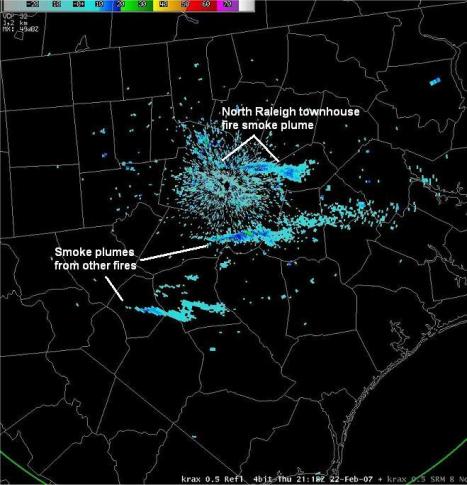
On Thursday, those factors played a part in dozens of fires across the western two thirds or so of our state, according to the National Weather Service in Raleigh, and they are in the process of compiling a case study on the event. In the meantime, it turned out that plumes of smoke from some of the fires around the region were visible on Doppler Radar Thursday afternoon, and there were also a number of slightly detectable "hot spots" that could be seen in infrared satellite imagery. The weather service posted two of those images, seen above, as a preview of the upcoming case study.
A list of the "Red Flag" criteria used by other weather and forest service offices around the southeast can be found at
http://gacc.nifc.gov/sacc/predictive/weather/RFcriteriaSummary.htm
Copyright 2024 by Capitol Broadcasting Company. All rights reserved. This material may not be published, broadcast, rewritten or redistributed.


