
By Mike Moss
A few days ago, it appeared we might be dealing with some sleet and freezing rain last night, as some computer models pushed very cold air near the surface a little farther south at that time than reality turned out to be. Since then, additional model runs that incorporated more extensive measurement of the storm system that was approaching from the west indicated that we would stay just warm enough for all rain, with especially warm temperatures across southern and eastern parts of the area. This played out rather nicely yesterday, with the temperature range actually exceeding the initial estimates. During the afternoon, temperatures spanned from upper 30s in northwestern parts of our viewing area to mid 60s in the southeast.
For the next 5 or 6 days, our temperatures will take a couple of excursions well below normal, something we've seen a lot of since about the middle of January. Some of the large scale pattern indicators are giving hints, though, that our temperatures may become more variable and perhaps trend toward normal to above normal readings for a while beginning around the middle of next week. Of course, looking that far ahead is fraught with potential for error in the computer model forecasts, but some of the generalities often work out reasonably well, even if the details are more problematic.
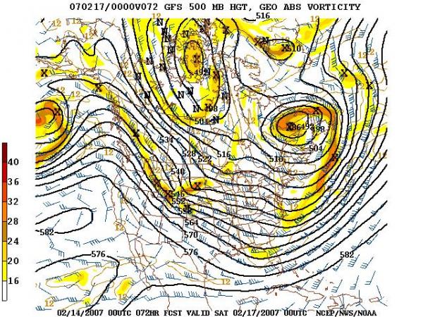
To illustrate, I've included a model forecast of the surface and 500 millibar patterns for this Friday evening at 7 pm, followed by a similar pair of images for Saturday a week later and finally an outlook for temperature anomalies from the Climate Prediction Center. On Friday a cold airmass remains in place over the eastern U.S., as indicated by the broad trough over the central and eastern parts of the country at 500 millibars, and the continued northwest flow at the surface and aloft, with high pressure off to our south and west. More cold air is evident northwest of us, and after a brief warmup Saturday, we'll cool down again Sunday into Monday.
Contrast those two images with the next two, valid on Saturday morning Feb 24th. Here, the 500 millibar pattern features a fairly deep trough over the western U.S. and a broad ridge, usually indicative of somewhat above normal temperatures, across the east. At the surface, a large high pressure center is in place over the Atlantic to our east, with a low to the west and a southerly flow across the entire southeast in between those two systems.
The last image in the series is an outlook for temperature probabilities for the period 8-14 days from now. While this covers a lot of time and is a very generalized product, it does indicate a pretty strong likelihood of temperatures above normal for the eastern half or so of the country, and vice versa out west.
While the cold air is in place for the next several days, there are hints of a couple of passing upper level disturbances that could conceivably generate a flurry or sprinkle in spots, but for now significant precipitation appears unlikely. Later next week, it appears we'll just be too warm for anything frozen for a while.
Copyright 2024 by Capitol Broadcasting Company. All rights reserved. This material may not be published, broadcast, rewritten or redistributed.


