
By Mike Moss
The title of this post refers both to two rounds of flurries that have crossed parts of our viewing area, last Thursday afternoon and then Sunday evening, and to some potential for wintry precipitation this coming Thursday. Both of the recent flurry episodes occurred with the passage of a strong upper level disturbance sweeping through from the west and very cold air spreading in aloft, but in both cases limited by a lack of moisture that meant the lift and instability associated with the disturbance was only able to tap into a rather shallow layer of moisture in the lower atmosphere to produce a few sprinkles and flurries.
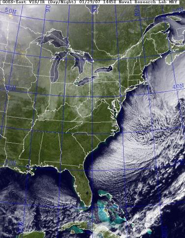
On Sunday evening, the upward motion produced by the system did manage to catch up to slightly deeper moisture over the northeastern-most corner of our state, so while north-central and much of northeastern Carolina received a brief sprinkle or flurry, there was a sure enough snowfall in the group of counties directly north of the Albemarle Sound, with Elizabeth City and Camden both reporting an inch of snow - it definitely stuck, too, as you'll see by enlarging the two visible satellite images I've included with the post. The first is a fairly wide angle true-color image from the Naval Research Laboratory, and the trick to interpreting the image is to note than there are no clouds over central and eastern NC when the image was taken. Nonetheless, there is a big white area over extreme southeastern VA and northeastern NC, where a nice snow cover remains in place. You'll also note a band of whitish colors in the western mountains of our state, also indicating some snow left on the ground from a round or two of flurries and snow showers there in the past day or two.
Also very prominent on this image are the plumes of stratocumulus cloudiness flowing east and southeastward along the coast all the way from Cape Cod or so down to central Florida. This is a common feature in the wintertime for a day or so following a strong cold front, when northwesterly winds push a very cold, dry airmass out over the ocean, and that airmass moistens and warms from below, making it unstable and prone to develop these expanding lines of clouds.
Since this is a pretty wide angle image of the eastern U.S., I also added a closer view centered on NC from the Aviation Digital Data Service. This black and white image also uses visible light, and gives a more detailed look at the features I mentioned above. In addition, it's interesting to note on this picture the "bay effect" cloud plume being produced by cold air flowing from the northwest along the Delaware Bay, and the lack of a similar plume along the Chesapeake. This is probably because the northwest winds are paralleling the Delaware Bay, but cutting across the Chesapeake so that the cold air isn't in contact with the warmer water long enough to get a plume going. If the winds were more from the north-northwest, the existence of the bay plumes would likely be reversed. Another feature to note on this image is a west-northwest to east-southeast band of air aloft that is perhaps a little colder and/or has relative humidity a bit higher than surrounding areas. There are no natural clouds apparent in this area, but it is marked by the formation of contrails by aircraft flying through it, which you can make out if you look closely along a line from northern AL east-southeast across GA into SC. This band lifted north during the day, and contrails became visible in our southern skies by early afternoon.
All this so far has to with the recent past, but we may be in line for another wintry weather event on Thursday. In this case, a cold high pressure area that moves into the region on Wednesday will be retreating to the east, but it may do so slowly enough to leave a moderately deep layer of cold air in place on Thursday, when it appears an upper level trough to our west will begin to direct some relatively warm, moist air our way aloft, and the process of lifting that air and turning it into precipitation may be enhanced by the development and approach of a surface low pressure area from the southwest. If an extension of the high pressure center east of us remains in place over our state, so that many of us retain a northeasterly low level wind as precipitation sets in on Thursday, it's possible the precipitation will begin as snow, or a mix of snow and rain if the precipitation is late to arrive. If precipitation becomes widespread and rates become sufficient, cooling due to evaporation and melting could lead to a few hours of mixed precipitation in the form of snow, sleet and freezing rain, with areas of rain perhaps becoming dominant over southeastern parts of the viewing area. Since it appears for now that the high to our northeast will be progressive, meaning it isn't locked into place by the large scale upper level flow across the central and eastern U.S., there is a decent chance that warming aloft will take place later in the day, leading any snow to become primarily freezing rain, rain and/or sleet before tapering off to freezing drizzle or just drizzle Thursday night into midday Friday. One factor that is likely to be a little different this go around is the potential for soil temperatures to be cooler than they have been due to repeated intrusion of colder air recently. However, they remain in the mid 30s to around 40 now and may still be a few degrees above freezing Thursday. Those temperatures would support accumulations if precipitation rates are high enough, but still resist much accumulation or persistence of snow or ice cover at low or intermittent rates.
I have to emphasize that I'm writing this at midday Monday and there are any number of variations to the evolution of this pattern that could result in the entire wintry scenario fizzling out and producing little in the way of precipitation or resulting in mainly rain, or perhaps becoming even more of a high impact snow and ice event. So far we haven't seen excellent consistency among different computer models, or especially good run to run continuity (meaning that each succesive update from a given models closely matches the previous one for the same point in the future) in the solutions individual models produce. So, as is often the case with winter weather around here, stay tuned!
Copyright 2024 by Capitol Broadcasting Company. All rights reserved. This material may not be published, broadcast, rewritten or redistributed.


