
By Mike Moss
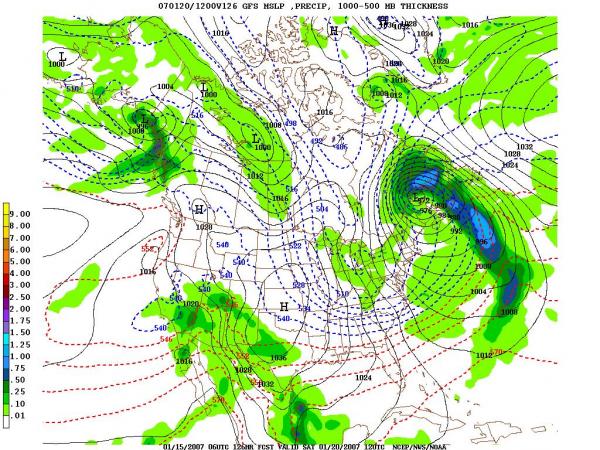
... At least for a while. After lots of comments about the lack of a winter for NC so far this season, we will have a couple of intrusions of much cooler air during the coming week. We'll start that process with the passage of a cold front along the leading edge of a fairly shallow cold air mass late tonight and tomorrow, followed by a deepening surge of cold but dry air tomorrow night into Wednesday, a slight recovery to seasonably mild temperatures toward the end of the week, and finally another blast of even colder, but again most likely dry air late Friday into Saturday. While it's too soon for much confidence in the specifics, it wouldn't be surprising if the second round of cold air leaves us with highs Saturday that struggle to climb out of the 30s. The first map available above (click on it for a larger view) shows the projected situation at 7 am Saturday morning, and we see a departing low to our north, an approaching cold high to our west, and tightly packed isobars indicating a strong pressure gradient, and thus stiff northwest winds, in between those two centers, advecting cold air our way from the Midwest and Great Lakes region.
Meanwhile, tomorrow's frontal passage will be a little different, and another example of the "non-diurnal trend" I wrote about in last week's blog. We'll probably start the day with temperatures in the range of our normal highs for this time of year (possibly as warm as mid 50s) and then trend downward midday into the afternoon, perhaps into the mid 40s by the mid-afternoon hours. High pressure west of us will keep some very chilly air flowing into the region on Wednesday, likely holding us in the lower 40s in spite of bright skies. Somewhat warmer air should try to edge into the region on Thursday, but a developing wave of low pressure along and north of the front to our south may bring an increase in moisture, and perhaps some light precipitation later in the day and into the evening, so that warming at the surface will be inhibited by a reinforced northerly flow, thickening clouds and evaporative cooling. There's even a slight chance we could start the event with a bit of sleet or flurries in a few spots, but the odds for that look pretty poor at this point.
All of this chillier weather comes in the wake of what now appears to have been the warmest calendar year on record for the United States as a whole, as noted in a recent report (see link above) from the National Climatic Data Center providing the climate highlights for the year. It just edged out 1998 as the warmest year in the 112 years that reasonably reliable data have been collected. Here in our state, it was just the 14th warmest on record (see the second map above), but the national ranking was heavily influenced by a large area of above normal temperatures across the nation's midsection and in the the northeast.
Copyright 2024 by Capitol Broadcasting Company. All rights reserved. This material may not be published, broadcast, rewritten or redistributed.


