
Well of course it will, but it seems like it has been ages since it rained at any length at my house in Apex and I know a lot of folks including farmers have been asking when is it we will see rain return to the area.
Our mean rainfall for the month of September is 4.26" at Raleigh Durham International and as of September 6th, the airport has officially reported .01"!!
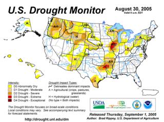
Surprisingly as of August 30th only part of North Carolina is classified by the U.S. Drought Monitor as being abnormally dry.
courtesy of the U.S. Dept. Of Agriculture
Now to tackle the question when will it rain again!? Honestly I don't know. There are a few factors we are watching that will affect our weather over the coming days that may either keep us dry or make it rain.
First we have Tropical Depression #16 sitting off the Florida coast in the Northern Bahamas. This will likely intensify into T.S. Ophelia over the next 24hours. This is exactly what we need to ease the dryness we have been experiencing lately. However at this time it does not look like it will directly impact North Carolina.
The winds above TD 16 are light so the steering mechanism is not there to move the storm quickly. There is a ridge of high pressure developing above the storm which is part of the recipe for intensification, plus the sea surface temperatures are in the mid-upper 80s. The ingredients are there for an intensifying storm.
Now at this time we have a surface area of high pressure sitting over New England which will initially keep the storm away from North Carolina. This surface area of high pressure may help steer the storm across Florida and perhaps into the Gulf of Mexico(oh no not another Katrina!?) Recall the circulation around high pressure is in a clockwise fashion, so the winds from the high will be blowing from east to west across Georgia and South Carolina. If the storm interacts with the surface high it should be pressed to the west.
There are two computer models, the European and the GFDL that actually do carry the storm headlong into New Orleans. There are others that keep the storm where it is with a slow drift to the north and then at the end of the week and into a weekend an upper level trough moves in from the Midwest and carries the storm into the Atlantic away from the U.S.
As it stands right now, there is much uncertainty in regards to the path of TD 16 soon to be Ophelia.
Now outside of the tropics our winds aloft are in such a fashion that we are having dry air advected into the area. Our awesome weather is like a double edged sword. Yeah it feels really good, but boy it is drying things out. Looking at the upper level winds for the next 2 weeks(again the tropics not withstanding) we may not see a pattern that would bring widespread rain into the area.
Again we will watch the depression...Perhaps it may bring us some much needed rain in the days ahead, but as it stands now as I write this, that scenario is not all that likely.
STAY TUNED!!!!!!!


