
For the second week in a row, we saw a substantial cold front cross North Carolina Thursday evening into Friday, followed by an unseasonably cool airmass setling into the state for the weekend. Unlike the previous weekend, though, this time instead of a pattern that resulted in clouds, periods of rain and very cool high temperatures, we have an especially dry airmass in place that led to bright sunshine and comfortably cool afternoon temperatures in the mid 60s, while overnight lows under mainly clear skies and light winds fell into the 30s, led to some areas of frost, and on Sunday morning Oct 15th managed to set a new record low of 33 degrees for the Raleigh-Durham airport, the old mark of 34 having last been reached in 1979.
While we experience a fairly quiet pattern as the coldest air settled into the region behind the second in a series of cold fronts that slipped through the state first Wednesday night and then Thursday night, a much more active scenario set up to our north in the vicinity of the Great Lakes, where a deep, slow-moving cold core low pressure vortex in the mid and upper levels drifted east across the region, destabilizing the mid levels of the atmosphere while cold air behind the frontal system at the surface rushed across the region Thursday and Friday, across Great Lakes waters that, being so early in the season yet, were still in the upper 50s to around 60 degrees, leading to a terrific amount of low-level instability as well, along with rapid evaporation of lake water into the otherwise relatively dry air flowing in behind the cold fronts. For a few locations downstream of the lakes, this translated into a record-setting early season lake effect snow storm.
In particular, Buffalo NY and surrounding communities were hit with a torrent of heavy, wet snow that fell at a rapid clip during the afternoon and evening of Oct 12th, and continued into the early to mid-morning hours of Friday the 13th. The result was a record 8.6 inches of snow at the Buffalo airport on Thursday and another record 14.0 inches on Friday for a total of 22.6. Weather observations through the course of the storm showed it to be a very interesting sequence, as temperatures just after midnight on the 12th were actually in the low 60s with a south to southeast wind. From there, the bottom fell out, with temperatures falling to around the freezing mark by early afternoon, and periods of rain through the morning changing over to snow around 1-2 pm, with gusty west to southwest winds blowing in from the northern reaches of Lake Erie. Through the night, temperatures stayed in the low to mid 30s with squalls of heavy snow and several periods of thunder and lightning. By afternoon, the snow was over, the clouds gave way to periods of sunshine, and temperatures climbed as high as 48 degrees. What a ride!
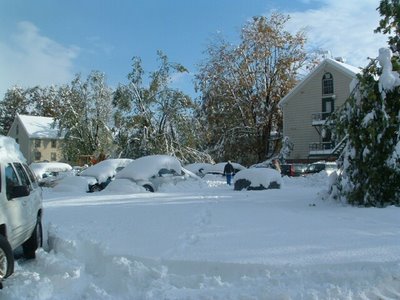
Especially in the earlier portions of the storm, the snow was wet and heavy, and the fact that it came so early in the season meant there were lots of leaves in trees to catch even more of the sticky snow than usual. This contributed to widespread power outages and bent or snapped tree limbs, quite a mess given the fairly short duration of the storm and temperatures for much of both days that were well above freezing.
To illustrate how things looked in the storm's wake, here are a few photos we received from Dottie Brezeale of Wake Forest. Her grandaughter Kachelle Stever, who is a student at Houghton College, took these shots in Seneca, NY. Thanks Kachelle and Dottie - I'm sure these images set Greg's snow-loving heart aflutter!


