
With the several rounds of moderate to heavy rain we've seen over the past few weeks (including a new record of 9 inches of rain for the month at RDU), flooding of streams and mainstem rivers has been an issue at times, especially in southern and eastern parts of our viewing area where runoff from throughout the watersheds in the region is able to collect the most water and send levels to their highest peaks.
For those who are affected by or simply interested in tracking the behavior of the rivers, there are several resources available that provide a significant amount of near-real time observed, as well as forecast, information at gauge sites along the waterways, along with historical information that places the flow rates or stage heights in a historical context, and in some cases includes a listing of what can be expected in the way of flooding impacts as a given river reaches successively higher levels above flood stage.
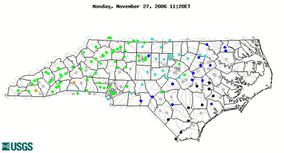
The two principal sources of information are provided by the National Weather Service, in the form of the Advanced Hydrologic Prediction Service (AHPS) page, where clicking a symbol (color-coded to show flood status) for a particular gauge location will pull up a graph of the observed and (in some cases) forecast levels, along with much of the other information mentioned above. Another source of information, that often includes some smaller stream locations, but not as much supplemental data, is from the U.S. Geological Survey streamflow page. There, you can start from a color coded state overview page that quickly gives a sense of how stream levels stand in relation to their historical norms.
The images below are examples of those available from the sites above. First, the map from the USGS shows near normal streamflow levels over western parts of our state as green dots, but the blues and black over the eastern half or so of the state indicate much above normal to record high flow rates. The graph below is from the NWS AHPS and shows the Tar River at Tarboro still just above flood stage but below the moderate flooding level this morning, with a forecast to fall below flood stage by Tuesday evening.


