Sandy hits both ends of NC
Hurricane Sandy delivered a double-fisted blow to North Carolina on Monday - high winds and waves in the east and a winter storm in the west - and authorities said they expect the twin hits to continue through at least Tuesday.
Posted — UpdatedGov. Beverly Perdue added 24 mountain counties to the declaration of emergency she issued Friday for the eastern third of the state, saying western North Carolina could receive 4 to 8 inches of snow from Sandy as the storm collided over the mid-Atlantic states with a cold front and exploded into a major winter storm.
"We're expecting heavy, wet snow and many slick roads," Perdue said.
Col. Michael Gilchrist of the North Carolina State Highway Patrol and Maj. Gen. Gregory Lusk of the North Carolina National Guard said their agencies have sufficient resources to handle emergencies both at the coast and in the mountains.
"We'll shift whatever resources we need to or move whatever resources are currently undeployed – and most of our resources aren't currently deployed – to wherever we need them," Perdue said. "We're going to stay on the job in eastern North Carolina until we can declare this emergency weather incident complete – both in the east and in the west."
North Carolina has been lucky so far in dealing with Sandy, the governor said, as the storm delivered a more direct hit to New Jersey, New York, Maryland and Delaware Monday evening.
Winds and rain buffeted the North Carolina coast for a third day on Monday. Jennette's Pier in Nags Head recorded 72 mph gusts, while Hatteras Village saw 64 mph winds and both Duck and Cedar Island were hit by 60 mph gusts.
By 8 p.m., Sandy had been reclassified as a post-tropical cyclone, with winds topping out at 80 mph as it slammed into the New Jersey coast.
WRAL Chief Meteorologist Greg Fishel said winds will continue to gust at 30 to 40 mph across North Carolina on Tuesday as Sandy moves toward the Great Lakes.
"Even though Sandy will be weakening, it still is going to have a big influence on our weather right on through (Tuesday)," Fishel said.
"It's a giant storm," Kill Devil Hills resident Dennis Anderson said. "It's killing us right now. The coastline is suffering."
Storm floods portions of Outer Banks
A storm surge combined with high tide Monday morning pushed water as far inland in Kitty Hawk as the U.S. Highway 158 Bypass. Water rose quickly to knee-deep levels in many parking lots, and authorities deployed jet skis to rescue some people.
"The ocean's going to come through in places where there is nothing to stop it, and quite honestly, you cannot stop the ocean," Kitty Hawk resident Peggy McCauley said.
The Stack 'Em High pancake house and other buildings became miniature islands.
"About once every 10 years, we get a bad one like this," Stack 'Em High owner Steve Kiousis said. "There's a whole bunch of things we always say. 'Lord doesn't give you more than you can handle.' 'God willing, creek don't rise.' But the creek's rising. What are you going to do about it?"
Jim Curnutte, who was using a canoe to get belongings to higher ground from a local RV park, said water there rose about 18 inches in 90 minutes.
"This is my first time for a big flood here. I've been here two years," Curnutte said. "It's a mess. A lot of people are losing stuff, and it's sad because these people have been through it many times already."
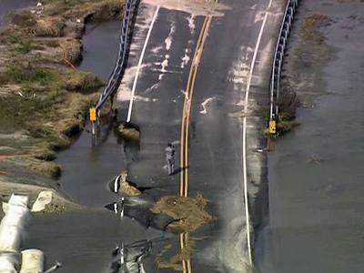
Waves washed over N.C. Highway 12, covering parts of the main artery on the Outer Banks with water and sand and closing sections of the road.
"We have ocean overwash in multiple places up and down the island," Dare County Manager Bobby Outten said. "There's ocean overwash and some deterioration of the pavement. As this thing moves out and the tide recedes, we'll see what we have."
Perdue said 18 to 24 inches of water was on N.C. 12, which hindered the ability of engineers with the North Carolina Department of Transportation to assess damage. DOT officials said they don't believe waves breached the highway, as they did last year in Hurricane Irene.
N.C. 12 was closed between the Bonner Bridge at Oregon Inlet and Rodanthe, north of Ocracoke village, and between Sea Level and Cedar Island in Carteret County. The Bonner Bridge was closed for inspection.
Waves battered Avalon Fishing Pier in Kill Devil Hills so much that sections were knocked out.
"One of our most favorite places on the whole island is getting destroyed right in front of our eyes," resident Frank Brown said. "The consistent impact (is the worst part of the storm). We could have 35 mph winds, and if it went on a few days, it would tear this place up just as much as 80 mph winds for four hours."
If winds shift direction, Kill Devil Hills resident Katie Burgus worries that water from the sound could be next to rise.
"I'm one house from the sound, and (water) is already coming up into my neighbor's yard, so that definitely is a concern," Burgus said.
Dare County offices closed shortly after noon, and county elections officials halted early voting for the rest of the day. Officials opened two shelters in the county for displaced residents.

Water in Ocracoke village had receded from up to 2 feet on Sunday to 6 to 10 inches by Monday afternoon.
Tidal flooding has partially covered U.S. Highway 70 east of Smyrna, Williamston and Stacy. All ferry service routes are canceled except for the Southport-Fort Fisher and Cherry Branch-Minnesott Beach routes.
Emergency crews and equipment are staged along N.C. 12 and are ready to assess damage as soon as it's safe. National Guard troops are at armory in Washington, ready to be deployed, and teams are prepped to distribute emergency supplies from a warehouse in Tarboro.
The DOT planned to start operating ferries Tuesday between Stumpy Point and Rodanthe to deliver supplies to Hatteras Island and help stranded residents escape, Perdue said.
Dare County officials said they expected a sound-side surge of 4 to 6 feet as winds from Sandy started coming from the west late Monday.
"This thing is going to linger so long, it tears up the coast," Anderson said. "If the thing would pass through – get in and get out – we're kind of all right."
South-facing beaches escape serious damage
Officials on North Carolina's central coast were counting their blessings Monday as Sandy spared the area during its northward trek.
"It's nice to say that we got lucky this time. I believe everybody took the storm seriously," said John Ford, the county's emergency services director.
Only one family stayed at a shelter the county opened Saturday evening, and officials have closed the shelter.
Herb Utter spent the day checking on his beachfront property in Atlantic Beach but didn't find any damage. He had moved all of his deck furniture inside, saying he didn't want a repeat of what he saw after Hurricane Irene last year.
"The ocean was rough," Utter said. "We were anxious a little bit. We respect it a whole lot. We see what it can do."
He said he didn't even see much beach erosion from Sandy.
"We were very lucky," he said.
Farther south, Sandy did leave behind some reminders, such as beach erosion at Kure Beach and minor flooding at Carolina Beach. The storm had minimal impact in the Wilmington area, as there was no major power outages or structural damage.


• Credits
Copyright 2024 by Capitol Broadcasting Company. All rights reserved. This material may not be published, broadcast, rewritten or redistributed.


