Forecasters: Floridians should prepare for hurricane
Forecasters warned that Tropical Storm Fay could bring hurricane-force winds to the Florida Keys as soon as Monday.
Posted — Updated
Fay could hit as a Category 1 or 2 hurricane, with winds perhaps reaching more than 100 mph, forecasters said Saturday. In anticipation, Gov. Charlie Crist declared a state of emergency for the state.
Flooding from Fay has killed four people in Haiti and the Dominican Republic, authorities said.
In neighboring Dominican Republic, a 34-year-old woman drowned when a family tried to cross a swollen river in a car, civil defense agency director Luis Luna Paulino said. The bodies of her missing 13-year-old niece and 5-year-old nephew were found Saturday afternoon, but her husband swam to safety.
The storm weakened slightly as it moved over Hispaniola but began to regain wind strength late Saturday. Fay's path will take it over the southern coast of eastern Cuba late Saturday or Sunday and over the island's west near Havana on Sunday night Monday, according to forecasters.
Around 5 a.m., the storm was about 125 miles south-southeast of Camaguey, Cuba and about 445 miles southeast of Key West, Fla. and had maximum sustained winds of 49 mph, according to the National Hurricane Center. To become a hurricane, sustained winds must be at least 74 mph.
"If the center of circulation stays on the south side of Cuba and over the warm waters, then we expect and the National Hurricane Center expects as well that Fay will become a hurricane before its able to make landfall in Florida. And that is bad news," WRAL Meteorologist Kim Deaner said.
Fay could hit the U.S. as a Category 1 or 2 hurricane, with winds perhaps reaching more than 100 mph (160 kph). A Category 1 has winds from 74-95 mph, and a Category 2 has winds from 96-110 mph.
"The official track brings it off the west coast of Florida Tuesday and Wednesday, however, the track is always uncertain and the entire peninsula of Florida needs to pay attention to the storm," said National Hurricane Center Meteorologist Christopher Juckins.
Florida's emergency management and county officials were monitoring the storm, and the city of Key West planned to open its emergency operation center Saturday. State officials in Tallahassee plan to activate the emergency operations center Monday, said Blair Heusdens, a spokeswoman for the state's Division of Emergency Management.
Juckins said if the storm veers to the east, it could pass over the Miami area early Tuesday.
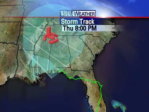
However, if it tracks farther west and remains over the Gulf of Mexico, it would hit landfall farther north and later in the week. A few of those models show Fay going farther east and hitting South Carolina or trailing along the North Carolina coast.
Deaner said she expects to Fay to track up the Southeast – but inland.
"And that's great news. It's going to be a great rainmaker," Deaner said.
• Credits
Copyright 2024 by WRAL.com and the Associated Press. All rights reserved. This material may not be published, broadcast, rewritten or redistributed.


