
The storm surge acategory 4hurricane can create is almost unimaginable, so professors atN.C. Statehave updated a 3-D computer model to put the storm surge into perspective.
The 3-D model has actually been used by forecasters in coastal Virginia and North Carolina for about six years.
However, a variety of improvements have dramatically increased the accuracy of the computer program.
National Weather Servicemeteorologists say the three-dimensional forecasting model has proven indispensable in predicting storm surges when a hurricane hits.
Right now, the technology is only advanced enough to analyze storm surges on the sound side of the coast. Meteorologists say they will take what they can get.
"You tend to forget about the threat from the sounds except for those people, I think, that have vital interest there, and it's important for them, really for the state as well, to be able to anticipate that threat," said Kermit Keeter, NWS Science Officer.
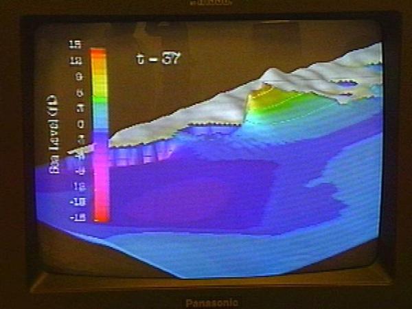
The older, 3-D model could forecast storm surges with a margin of error of several feet. That margin has narrowed considerably.
N.C. State professors Lian Xie and Leonard Pietrafesa have added new variables to their 3-D model to increase its precision.
The new model takes into account how much a hurricane dissipates upon landfall, water flow speed and direction at 11 different depths.
"Besides Dr. Pietrafesa and myself, we have eight doctoral students working in my group, and one post-doc working in my group to develop the whole model system," said Xie.
The professors are also working on a computer model that will predict storm surges on the ocean side. It is still in the developmental stages.
Monday, Emergency Management officials told North Carolina residents to prepare for the worst.
Secretary of Crime Control and Public SafetyRichard Moore said each forecast for Hurricane Floyd poses worse possibilities for our state.
He says the current track of the storm would take it through an area least prepared to deal with its effects.
"It's almost impossible to predict the exact path of a storm this far out, but almost every variable there has something bad for the state of North Carolina in it," said Moore.
Moore urges all residents of the state to have a three-day supply of food and other needs. The State Emergency Operations Center will go into full-activation Tuesday morning.
As a strong category 4 hurricane, Floyd would join some notorious company if he makes landfall. He could cause damage like we have never seen. Category 1Winds:74-95 mphCategory 2Winds:96-110 mphExamples:Bonnieand BerthaThe wind can cause damage, but flooding is usually the major concern with this size storm.Category 3Winds:111-130 mphExamples:FranThese storms cause serious wind damage and severe coastal flooding.Category 4Winds:131-155 mphExamples:Andrew and HugoThe winds damage even the most sturdy structures, and the 18-foot storm surge can flood low lying areas several miles inland.Category 5Winds:Over 155 mphExamples:Since 1925, only two have hit the U.S. The most recent was in 1969 when Hurricane Camille struck the Gulf Coast leveling almost everything in its path. Many buildings that were lucky enough to survive the wind, crumbled under the pressure of a massive storm surge.
• Credits
Copyright 2024 by Capitol Broadcasting Company. All rights reserved. This material may not be published, broadcast, rewritten or redistributed.


