
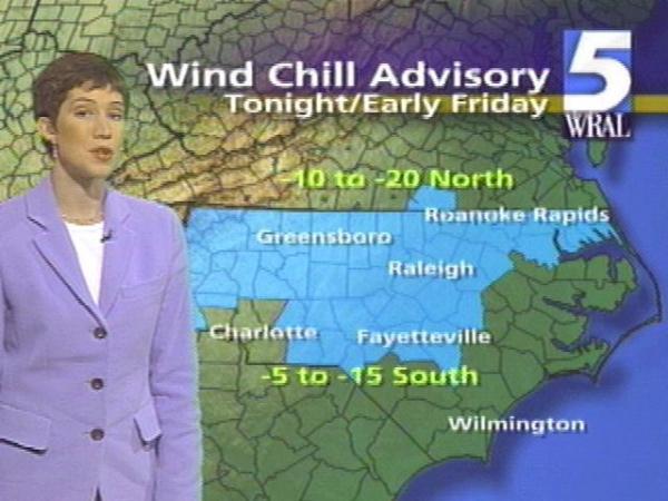
Strong northwesterly winds will drop wind chills in the area to 10 to 20 degrees below zero.
school systems canceled classeson Thursday, including Chapel Hill-Carrboro, Chatham, Durham, Orange, Johnston, Nash-Rocky Mount, Wake, and Wilson counties. It was the third consecutive day that winter weather forced schools to cancel classes. -->
Severalschool systemshave already announced their plans for Friday: Granville, Orange and Vance County schools will open two hours later, and Caswell, Chatham, Franklin, Person, Wake and Warren county schools will open one hour late.
Carolina Power & Lightcustomers were without power early Thursday morning -- 1,400 in the Rocky Mount area. Power had been restored by 7 a.m.Duke Powerreported about 1,000 customers lost power, due in part to trees down in Chapel Hill.
About two inches of snow fell in downtown Raleigh, with heavier amounts north and west of the city. About three to four inches of snow were on the ground in Durham. The heaviest snow fell along the Virginia border. Greensboro received about 3 inches.
The state Highway Patrol is recommending that drivers stay off the roads as much as possible Thursday until higher temperatures and sunshine melt the slush. Major thoroughfares have been cleared, but many secondary roads and subdivisions are slick. Some drivers are reporting icy patches on the roads under the snow.
At 6 a.m., the Highway Patrol and Raleigh police were only handling a handful of accident calls. That was not the case on Tuesday morning, where temperatures in the mid 20s and snowfall during the morning rush hour led to hundreds of accidents.
Cumberland County authorities say they have had no problems with traffic accidents there, where the main and secondary roads are wet but clear. Schools there are operating on a normal schedule.
The snow started to taper off in Wake County around 4:30 a.m., after about four and a half hours of falling.
The sun will be out midday to help dry out the roads, but it will be windy, says meteorologist Mike Maze. Highs will range from upper 30s to low 40s across the viewing area. -->
The next possible precipitation could come Sunday in the form of snow or rain. Maze said it is too early to accurately predict the form.
Maze said long-range forecasting models call for high temperatures to stay in the low to mid 40s next week.
The state Highway Patrol communication center normally receives about 1,300 calls a day. Tuesday, operators answered about 2,400 calls.
The lines are supposed to be for wrecked cars, but instead people are calling about road conditions, jamming the phones and making it more difficult for the people who need help to get it.
"We run into the situation with people having a little bit of cabin fever and wanting to know road condition reports, and they're calling our emergency lines for that and that causes tremendous problems," said Sgt. Jeff Winstead.
The DOT is also getting ready. Road crews used about 500 tons of salt on Tuesday's storm and asked Virginia for 500 tons to replace it. The trucks from Virginia started arriving around 9:30 p.m., while DOT drivers took a break.
"I sent everybody home about 4:30, told them to go get some supper and take a nap and be back at 12," said maintenance engineer Jerry Linder. -->
• Credits
Copyright 2024 by Capitol Broadcasting Company. All rights reserved. This material may not be published, broadcast, rewritten or redistributed.


