Tornado Warnings Issued for Wake, Durham, Orange Person and Chatham Counties
Posted — Updated
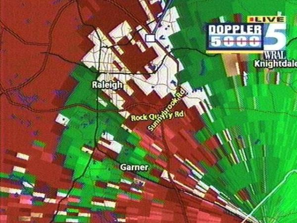
The National Weather Service has issued a Tornado Warning for Person County until 6 p.m. and the same warning for Durham, Franklin, Granville and Orange counties until 6:30 p.m. Friday. Wake County is also under a Severe Thunderstorm Warning until 6:30, and a Tornado Watch remains in effect for Central North Carolina until 12 midnight Friday. Deadly tornadoes swept through Georgia Friday morning, and Triangle forecasters are keeping a close watch on the storm system that caused them. The National Weather Service said at noon that there is a "moderate" chance severe weather could reach this area later today.
Reports of damage have begun trickling in. Police are out in force attending to accidents, and there are scattered power outages
At 6:50 p.m., Jack Edwards, a WRAL employee and Garner resident spoke live on the air about his experience with a tornado.
As of 6:30 p.m. Friday, there were no reports of serious damage from the Holly Springs twisters.
At noon, there were only some light showers and cloudy skies in the Triangle and that trend was expected to continue for several hours. One spot of severe weather caused a morning severe thunderstorm warning near Boone, but it expired without incident.
The western part of the state remained under a tornado warning until 1 p.m. Friday.
WRAL-TV5 MeteorologistMike Mazesaid conditions in the WRAL viewing area would exist later Friday for severe weather to occur.
Meanwhile, Johnston Emergency Management says it's workers have measured the Neuse and found that, while it had been expected to crest Saturday at 22 to 23 feet, it crested 18 1/2 feet Friday afternoon. They say this means it's not nearly as bad as they predicted. They say they now expect very little flooding of the Neuse.
Residents downstream of the spillway at the Falls Lake Dam had been keeping a close watch on flood levels. People in Clayton, Smithfield, Goldsboro, Kinston and points in between were alert to the possibility of flooding as the Neuse River began its flow downstream. At noon Friday, the lake level had risen to within two feet of the top of the dam. Officials thought the level might peak above the high water mark it made during and after Hurricane Fran, at about 263 feet.
Falls Lake Project Leader Lloyd Williamson says everyone is hoping the water recedes soon. Whether it does or not, though, pressure on the dam will likely have to be released.
Williamson says the plan is to open floodgates halfway Saturday and open them all the way Sunday.
Within 14 hours, any released water will reach Clayton. It takes 20 hours to reach Smithfield, 80 hours to Goldsboro, and 128 hours to reach Kinston.
• Credits
Copyright 2024 by Capitol Broadcasting Company. All rights reserved. This material may not be published, broadcast, rewritten or redistributed.


